January 26, 2010

Google's Geographies of Religion

“Religion is probably, after sex, the second oldest resource which human beings have available to them for blowing their minds”
Susan Sontag

Following up on the earlier discussion of the user-created geographies of religion, the following maps simultaneously display all four religious references (Allah, Buddha, Hindu, Jesus) in order to visualise distinct religious cyberscapes. Below we see the data on a global scale. This map clearly mirrors many of the expected religious geographies of the offline world: references to Allah being most prominent in the Middle East, references to Buddha being most prominent in East Asia, references to Hindu being most prominent on the Indian subcontinent and references to Jesus being prominent in Europe and much of the Western Hemisphere.


Interestingly, there are are no large-scale homogeneities in the data and this reflects the sometimes scattered nature of religious practice in the world. Looking at the below map of user-created religious references in Europe, it can been seen are a significant number of places (e.g. parts of Switzerland, Germany, the UK) in which there are more references to Buddha than any other religious terms. Likewise there are parts of Belgium and France with a dominant number of references to Allah, and parts of the UK with a dominant number of reference to Hindu. (The cluster of Hindu references on the Estonian islands of Saaremaa and Hiiumaa is tied to a village named Hindu rather than religious practice). Also of note is the transition of religion as one moves eastward and southward with references to Allah becoming more prevalent in Muslim North Africa and Turkey. However, one can also see how this is far from monolithic with references to Jesus also sprinkled throughout this region as well as strong clusters in Israel/Palestine as well as within Armenia.


In Asia a similar amount of diversity can be seen. The United Arab Emirates is a particularly interesting example. While officially a Muslim country, Indians make up the largest demographic presence and the dominance of references to Hindu (rather than Allah) is likely a reflection of this fact. Likewise the Malay Peninsula and the Indonesian archipelago (particularly the island of Java) illustrate the complexity of religious practice in this region. References to Buddha, Allah and Hindu are all in evidence on Java. Other examples include the predominately Buddhist nation of Sri Lanka with some Hindu areas to the North and the difference between Pakistan (more Allah) and India (more Hindu).


Finally, it is informative to include one additional map with this set. Here we included placemarks that reference the word ("sex"), a popular and international used term with very different connotations than the religious keywords used earlier. The purpose of including this term is to compare user interest in religion to user interest in sex. If (as some say) the three topics to avoid in polite conversation are religion, sex and politics it seems only right that this Internet blog (the antithesis to polite conversation if there every was one) takes on the question. Sadly, the inclusion of politics will have to wait until another day.

In Asia there are very few places where there are more references to sex than Allah, Buddha, Hindu or Jesus.


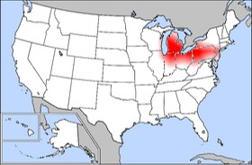
Constrasting this is Western Europe (especially the UK and Scandinavia) and North America (especially the East and West Coasts) there are more references to sex than any of the four religious terms that we searched for. The distribution in the U.S. mirrors our early maps of the virtual bible belt and church-bowling-firearms-strip clubs. There are, however, exceptions such as the Iberian countries of Spain and Portugal which continue to show more references to Jesus.

So it would seem that Susan Sontag's observation has some merit, at least in the European and North American context.

Metropolitan Level Maps of Cyberscapes

Over the next weeks we will begin to post a range of metropolitan level maps of user generated Google placemarks. These maps illustrate one of the "cyberscapes" of these cities, i.e., the cloud of geo-coded data in cyberspace which provides an additional layer for human interaction.

Cyberscapes, consist of multiple layers, e.g., Google placemarks, Wikipedia articles, geotagged Flickr, Twitter Tweets, etc., but the metro maps are limited to user generated placemarks.

The examples of New York's and Capetown's cyberscapes below illustrate how these cyberscapes vary over location and topic. The white box in each map indicates the area for which we have data. Stay tuned....


All User Generated Placemarks
New York City, January 2009


User Generated Placemarks Referencing Crime
New York City, January 2009


All User Generated Placemarks
Cape Town, South Africa, January 2009

User Generated Placemarks Referencing Crime
Cape Town South Africa, January 2009


Upcoming Cites: Baghdad, Beijing, Buenas Aires, Cape Town, Chicago, Dublin, Hong Kong, Jerusalem, Lagos, Lexington (KY), London, Los Angeles, Mexico City, Mumbai, New Orleans, New York, Pyongyang, Rio de Janeiro, San Francisco, Tallinn, and Washington D.C.

January 24, 2010

Where do people Make it Rain'?

I make it rain. I make it rain on them.
-Fat Joe featuring Lil' Wayne, "Make it Rain"

No surprises here (except for FloatingSheep's mastery of slang). The folks in Las Vegas make it rain. No, not precipitation. The kind defined by the Urban Dictionary as "When you're in da club with a stack, and you throw the money up in the air at the strippers. The effect is that it seems to be raining money." Indeed.

It shouldn't startle anyone that the largest city in the only US state where prostitution is legal also has the most user-generated references to strip clubs. Contrasting its usual ranking in the urban hierarchy of user-generated geographic information (i.e., somewhere in the middle), Las Vegas is undoubtedly considered by the collective intelligence of the Internet as the place to go to see the clothes come off.

But it is also clear that this phenomenon is national with clusters of strip club reference throughout the U.S. with Florida, Chicago, Detroit, Toronto, Montreal, New York-New Jersey (Bada Bing!) and Portland standing out in particular. Does Las Vegas retain its penchant for seedy entertainment when the raw number of hits are normalized by both the average number of mentions of 'strip clubs' in user-generated placemarks and the relative specialization at each point (values divided by the number of mentions of "1")?

Even when the raw values of user-generated placemarks are normalized by these two measures (with values showing less-than-average specialization excluded), Las Vegas remains the national hotbed for strip clubs by a considerable margin. But what explains the relative prevalence of strip clubs in the area around Aiken, SC? Or most of Connecticut, for that matter?

Clearly further research is needed but that's NOT what we mean. We're more than content to let it remain one of life's little mysteries for now.

January 20, 2010

What do church, bowling, firearms and strip clubs have in common?

One answer (or at least the one we're willing to print) is that they all represent ways in which Americans can spend their time. But which parts of North America are more focused on one or the other? Or, more precisely, where are the resources for each activity more available? Using the number of listings indexed by the Google Maps directory[1], the map below visualizes the comparative prevalence of churches, bowling alleys, guns and strip clubs across the US (as well as parts of Canada and Mexico). Each point is color coded according to which activity had the most number of hits in the Google Maps directory.

Upon first glance, it is easy to see the relative supremacy of two topics, churches (in blue) and guns (in green), which cover most of the points in North America. Churches dominate throughout most of the southeast and upper midwest (echoing our findings from the virtual bible belt map) while the Northeast, the West and much of Canada show a higher number of listings for guns. One should not, however, interpret this to mean that guns are more prevalent in Canada than the southern U.S. (which clearly does not equate with the offline reality). Instead, the Northeast and Canada have relatively fewer listings for churches than in the south, leading them to be color coded with the next leading activity, i.e., guns. Likewise, there are plenty of gun listings in the southeastern United States, they are simply overshadowed by the listings for churches.

Of more interest are the small pockets in which either bowling alleys or strip clubs are most numerous, bucking the near-universal trend focused on guns and church. For example, there is a prevalence of strip clubs around Las Vegas and Reno, Nevada, as well as Los Angeles, California. Additionally, Canadian cities seem particularly well represented with clusters in Montreal, the Buffalo-Toronto corridor and the Seattle-Vancouver region. Interestingly enough, there seems to be some correspondence (especially in the Northwest US and Toronto) with our map outlining user-generated definitions of fun.

The small pockets of strip clubs around eastern Tennessee along the North Carolina and Georgia borders seem inexplicable, until one considers the advertising landscape along the I-75 corridor, in which religious and pornographic iconography are ubiquitously juxtaposed.

The few areas in which the bowling alleys outnumber churches, guns and strip clubs, are more difficult to explain. There seems to be little rhyme or reason for these bowling hot spots, as they do not correspond well with places with a relative specialization in bowling alleys. The areas shown in red are exclusively rural, so their classification may simply be a result of there not being much else there. Or their residents could really like their bowling. In any case, we plan on contacting Robert Putnam and seeing if he can offer any insight on this.


[1] Google Maps directories are drawn from a range of sources such as yellow page listings. This category is distinct from and excludes user-generated placemarks used in other maps found on Floatingsheep.

January 18, 2010

Rust Belt Bowling

What is one to make of Robert Putnam's now-infamous assertion that despite bowling reaching an all-time high in popularity, it's new found nature as a solitary activity is indicative of a decline in civic engagement, increasing social isolation and alienation amongst Americans? Although it cannot support any definitive conclusions, the relative concentration of listings of bowling alleys in the Google Maps directory[1] tells an interesting story about where this process of social isolation might be taking hold.


The above map shows places in which the number of listings for bowling alleys in a single place exceeds the national average number of listings by 20% (i.e., only indexed values >1.2 are shown). Although some of these places continue to show the dominance of urban areas (the larger a place is the more bowling alleys it might have), this explanation is far from sufficient. The maximum indexed value is located in Southfield, Michigan, a suburb of Detroit, a highly unlikely location, given that listings in Google Maps directory are concentrated in major cities such as New York City, Los Angeles, Chicago and San Francisco. Further inspection shows that much of the activity mirrors the extent of the American Rust Belt, a region formerly known for its dominance in the manufacturing industry, now known more for its collective decline in the face of a severe economic downturn.

So what does this spatial correlation mean? A loose application (and we mean loose) of the theories of Max Weber (the 'iron cage') and Karl Marx (alienation of labor) might show that due to their full integration into the world of capitalist manufacturing, individuals living throughout the Rust Belt have turned to bowling as a refuge from their work lives, or lack thereof. It could be possible however, contra Putnam, that Rust Belt citizens have actually turned to bowling as a way of reconnecting with their community, rather than disengaging from it.

Or (stepping back from the brink of Germanic socio-economic theory) this map could simply highlight the cultural geography of a leisure activity with strong associations to the geography of early to mid 20th century manufacturing centers. Unfortunately for us, however, Google Maps cannot tell us why people bowl or whether they are bowling alone [2]. So for now, we remain wondering whether bowling is indicative of a resurgence of community or growing individualism. Let along the more troubling question of how Wii bowling fits into this.

[1] Google Maps directories are drawn from a range of sources such as yellow page listings. This category is distinct from and excludes user generated placemarks that we use in other maps.

[2] Or at least not until the release of Google BowlCam which is now in beta testing.

January 13, 2010

Floatingsheep in the Lexington Herald-Leader, or Santa Likes it Hot

Sometimes analog is better than digital. This is especially true when being featured on the front page of the the Lexington Herald-Leader on Christmas Eve. Belated scans of the newspaper article about our Christmassy maps are below...

January 11, 2010

Unintentional map art

It's not quite toying with map projections, but sometimes trial-and-error in choosing map symbology can lead to some pretty interesting errors...
You can barely make out the outlines of the United States (including Hawaii and Alaska), Canada, Mexico and the Caribbean under the blanket of graduated circles. In the end, we decided to go with an amended symbology, as we felt that the message conveyed by this map was a bit less informative that we would like.