

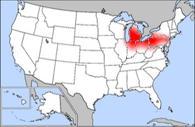
The above map shows places in which the number of listings for bowling alleys in a single place exceeds the national average number of listings by 20% (i.e., only indexed values >1.2 are shown). Although some of these places continue to show the dominance of urban areas (the larger a place is the more bowling alleys it might have), this explanation is far from sufficient. The maximum indexed value is located in Southfield, Michigan, a suburb of Detroit, a highly unlikely location, given that listings in Google Maps directory are concentrated in major cities such as New York City, Los Angeles, Chicago and San Francisco. Further inspection shows that much of the activity mirrors the extent of the American Rust Belt, a region formerly known for its dominance in the manufacturing industry, now known more for its collective decline in the face of a severe economic downturn.
So what does this spatial correlation mean? A loose application (and we mean loose) of the theories of Max Weber (the 'iron cage') and Karl Marx (alienation of labor) might show that due to their full integration into the world of capitalist manufacturing, individuals living throughout the Rust Belt have turned to bowling as a refuge from their work lives, or lack thereof. It could be possible however, contra Putnam, that Rust Belt citizens have actually turned to bowling as a way of reconnecting with their community, rather than disengaging from it.
Or (stepping back from the brink of Germanic socio-economic theory) this map could simply highlight the cultural geography of a leisure activity with strong associations to the geography of early to mid 20th century manufacturing centers. Unfortunately for us, however, Google Maps cannot tell us why people bowl or whether they are bowling alone [2]. So for now, we remain wondering whether bowling is indicative of a resurgence of community or growing individualism. Let along the more troubling question of how Wii bowling fits into this.
[1] Google Maps directories are drawn from a range of sources such as yellow page listings. This category is distinct from and excludes user generated placemarks that we use in other maps.
[2] Or at least not until the release of Google BowlCam which is now in beta testing.


I think religion is older than sex
ReplyDeletehey i love your site how did you get ur labels in the sidebar too be cool
ReplyDelete